 NERC Data Catalogue Service
Energy Resources
Type of resources
Topics
Keywords
Contact for the resource
Provided by
Years
Formats
Representation types
Update frequencies
Resolution
-
This dataset contains 30-minute observations of land-atmosphere exchange of net ecosystem carbon dioxide exchange and sensible and latent heat measured over the growing season of a maize crop grown for bioenergy in Yorkshire, UK. Turbulent fluxes were measured using the micrometeorological eddy covariance method between 02/06/2021 and 10/10/2021. The dataset also includes weather and soil physics measurements. Full details about this dataset can be found at https://doi.org/10.5285/9b6c2393-b751-46b4-b139-71ca09321139
-
The data consists of names, types, voltages, constraint status and national grid references for 56,865 electricity substations (33 kV or larger) in Great Britain in 2018. It was compiled from information on individual transmission or distribution network operator websites and interpreted to produce a classification of constraint status (where applicable). The data set was compiled from information on individual transmission or distribution network operator websites. The work was funded by the Natural Environment Research Council Award NE/M019713/1. Full details about this dataset can be found at https://doi.org/10.5285/0eed5c99-f409-4329-a98e-47f496bb88a2
-
A compendium of earthworm data sources and associated information from the UK and Ireland, 1891-2021
This dataset presents a compendium of field-based earthworm data sources and associated meta-data from across the United Kingdom and Ireland (‘Worm source’). These were compiled up to 2021 and include 257 data sources, the earliest dating back to 1891. Source meta-data covers the type of quantitative earthworm data (i.e. incidence, abundance, biomass, taxa), methodological details (e.g. sampling method/s, location/s, whether sampled plots were natural or experimental, sampling year/s), and environmental information (e.g. habitat/land-use, inclusion of climate data and basic soil properties). Data sources were collected through literature searches on Web of Science and Google Scholar, as well as directly from original authors/data holders where possible. The data sources were compiled with the aim of gathering quantitative data on earthworm species and populations to develop earthworm abundance and niche models, and toward a modelling framework for earthworm impacts on soil processes. This work is part of the Soil Organic Carbon Dynamics (SOC-D) project funded by the NERC UK-SCAPE programme (Grant reference NE/R016429/1). Full details about this dataset can be found at https://doi.org/10.5285/1a1000a8-4e7e-4851-8784-94c7ba3e164f
-
The dataset contains the chemical composition of anaerobic digestates derived from source-segregated food waste & agro-waste, with and without biomass ash, after the addition commercial polymer to enhance dewaterability. A preliminary experiment was carried to determine the type of polymer and its optimum dose (WP1A1). Then, polymer was added to digestate and digestate/ash blends, let react for short-time and physically separated into their fiber and liquid fractions (WP1A2). These experiments were carried out in the laboratory during 2016, being measured via a combination of internal and external laboratories. Preliminary experiment (WP1A1) contains data on polymer type, dose and mass added as well as supernatant and solids separated. Main experiment contain data on masses (dry & total solids), supernatant volume, pH and plant macro-nutrients profile (total concentration of Ca, Mg, P, K, TKN and S). Full details about this dataset can be found at https://doi.org/10.5285/2977fc7b-f83e-4696-b06b-2f589ffa6965
-
This dataset contains nitrogen data from nitrate, ammonium and nitrite, total nitrogen and carbon data, and elemental composition data from anaerobic digestate and biomass ash from UK bioenergy production. Anaerobic digestate was sampled 8 times from different industrial scale plants across the UK between January 2015 and January 2018 and biomass ash was sampled in January 2015 and June 2016. Anaerobic digestate was sourced from segregated food waste (mainly household waste), pig slurry, maize silage, vegetables waste, sweet corn waste, aerobically treated food waste, food manufacturer waste and other biodegradable sludge from within the UK. Biomass ash, both fly and bottom ash, from virgin and recycled wood was sourced from three sites within the UK and one from Spain. All laboratory analyses were undertaken at Lancaster University using standardised methods. The data were collected as part of the research grant, Developing a suite of novel land conditioners and plant fertilizers from the waste streams of biomass energy generation. The research was funded by NERC, award NE/L014122/1. Full details about this dataset can be found at https://doi.org/10.5285/990c54f6-5c92-4054-8bfa-953533a89149
-
This dataset contains information about predicted future erosion hazards to electricity transmission towers at a site in the Mersey River valley. River channel change and floodplain erosion rates were simulated under 6 hypothetical flow scenarios, covering the years 2018 to 2050. These scenarios include: “baseline” where we assumed the 32 years of flow from 2018 to 2050 matched the preceding 32-year period; and “plus 10, 20, 30, 40 & 50%” where we assumed daily averaged flow magnitudes increased by 10, 20, 30, 40 or 50%, depending on the scenario. Simulations were run using the CAESAR-Lisflood landscape evolution model. Input files that were used to drive the simulations include a 15-metre resolution DEM covering a ~4.5 km long reach of river valley, and daily-averaged flow inputs (m3 s-1). Landscape changes over time were extracted at the locations of each electricity transmission tower, with the severity of erosion used to judge the relative risks of each tower from future climate change. The work was supported by the Natural Environment Research Council (Grant NE/S01697X/1) as part of the project: ‘Erosion Hazards in River Catchments: Making Critical Infrastructure More Climate Resilient’. Full details about this dataset can be found at https://doi.org/10.5285/78bc21a9-39e0-4efc-992c-5587439fe6be
-
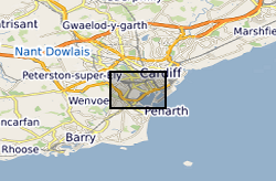
Groundwater temperature data from a shallow urban aquifer in Cardiff, Wales, UK between 2014-2018. Monitoring was undertaken as part of the ‘Cardiff Urban Geo-Observatory’ project . Boreholes are located within the urban area of the City of Cardiff, Wales, UK. The majority of temperature sensors were installed within boreholes that monitor a shallow Quaternary aged sand and gravel aquifer, however the made ground and the Triassic Mercia Mudstone also represented. Temperature sensors installed in 53 boreholes, between depths of 1.5m and 12- m below ground, with measurements every 30 minutes. The dataset comprises of just over 3.5 million temperature measurements. Monitoring was undertaken by the British Geological Survey and was designed to address knowledge gaps of subsurface urban heat island and it use for heat recovery and storage. Metadata Report http://nora.nerc.ac.uk/id/eprint/525332/